![](/images/other/stat-length.png)
![Tocht Stappen Le Vauclin - GabyG. Pointe du Vauclin - Photo](https://media.geolcdn.com/t/1900/400/ext.pjpeg?maxdim=2&url=https%3A%2F%2Fservices.sitytrail.com%2FGeolivesWS%2FDownloadMedia.ashx%3FTrailID%3D701179%26Media%3Dfix__20170219080108.jpg)
GabyG. Pointe du Vauclin
GabyG
Gebruiker GUIDE
![Lengte](/images/other/stat-length.png)
![Max. hoogte](https://static1.geolcdn.com/siteimages/upload/files/1508320355ic_sort_altitude_max_24dp.png)
![Positief hoogteverschil](https://static1.geolcdn.com/siteimages/upload/files/1508320355ic_sort_den_pos_24dp.png)
![Km-Effort](/images/other/stat-length.png)
![Min. hoogte](https://static1.geolcdn.com/siteimages/upload/files/1508320355ic_sort_altitude_min_24dp.png)
![Negatief hoogteverschil](https://static1.geolcdn.com/siteimages/upload/files/1508320355ic_sort_den_neg_24dp.png)
![Boucle](https://static1.geolcdn.com/siteimages/upload/files/16400158638029165_repeat_loop_refresh_sync_direction_icon.png)
![Stappen](https://static1.geolcdn.com/sitytour/trail-icons/101.png)
3h09
Moeilijkheid : Medium
![Scan deze QR-code om de tocht te openen in de SityTrail-applicatie](https://capi.geolives.com/qq0zvz2zws4bq2lad0pu/sitytour/trails/701179/qr.png?size=200)
Gratisgps-wandelapplicatie
Over ons
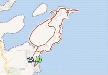
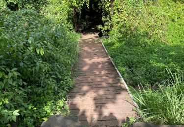
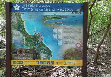
Tocht Stappen van 12,3 km beschikbaar op Martinique, Onbekend, Le Vauclin. Deze tocht wordt voorgesteld door GabyG.
Beschrijving
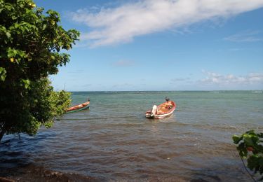
Pointe du Vauclin. Belle randonnée du dimanche, sur deux parcours, attention au soleil! beaucoup de passages ombrager.
*) Le grand parcours de 6.7 km, longe la cote et donne de superbes points de vues pour les chasseurs d'images et de bordures côtière.
*) Le petit parcours de 5.3 km, accès directe par la mangrove, puis passage dans le petit village de petite grenade.
Les deux parcours d'une manière ou autre, vous permettent de vous apprivoiser avec la mangrove. Respectez-la et gardez notre Martinique propre. Chiens tenus en lesse uniquement.
Plaatsbepaling
Opmerkingen
Wandeltochten in de omgeving
![Tocht Stappen Le Vauclin - 2eme parcours de la pointe du vauclin et trou cochon - Photo](https://media.geolcdn.com/t/375/260/fd5f5f70-4900-44d9-a18e-c60706827007.jpg&format=jpg&maxdim=2)
![Stappen Stappen](https://static1.geolcdn.com/sitytour/trail-icons/101.png)
Stappen
![](/images/other/stat-length.png)
![](https://static1.geolcdn.com/siteimages/upload/files/16400158638029165_repeat_loop_refresh_sync_direction_icon.png)
![Tocht Stappen Le Vauclin - Randonnée scolaire - Photo](https://media.geolcdn.com/t/375/260/355de9f6-e0cf-496c-9f2e-61b56f53532f.jpg&format=jpg&maxdim=2)
![Stappen Stappen](https://static1.geolcdn.com/sitytour/trail-icons/101.png)
Stappen
![](/images/other/stat-length.png)
![](https://static1.geolcdn.com/siteimages/upload/files/16400158638029165_repeat_loop_refresh_sync_direction_icon.png)
![Tocht Stappen Le Vauclin - Petit parcours Macabou - Photo](https://media.geolcdn.com/t/375/260/c067cce8-5144-49fb-8b93-50d81e97a77c.jpg&format=jpg&maxdim=2)
![Stappen Stappen](https://static1.geolcdn.com/sitytour/trail-icons/101.png)
Stappen
![](/images/other/stat-length.png)
![](https://static1.geolcdn.com/siteimages/upload/files/16400158638029165_repeat_loop_refresh_sync_direction_icon.png)
![Tocht sport Le Vauclin - Boucle du Vauclin - Photo](https://media.geolcdn.com/t/375/260/2fa56dd7-e03f-43f3-b48e-41c427fef873.jpg&format=jpg&maxdim=2)
sport
![](/images/other/stat-length.png)
![](https://static1.geolcdn.com/siteimages/upload/files/16400158638029165_repeat_loop_refresh_sync_direction_icon.png)
![Tocht Stappen Le Vauclin - Trou cochons - Photo](https://media.geolcdn.com/t/375/260/abe9d043-3147-4ace-9a6e-cedeae2bb0f3.jpg&format=jpg&maxdim=2)
![Stappen Stappen](https://static1.geolcdn.com/sitytour/trail-icons/101.png)
Stappen
![](/images/other/stat-length.png)
![](https://static1.geolcdn.com/siteimages/upload/files/16400158638029165_repeat_loop_refresh_sync_direction_icon.png)
![Tocht Stappen Le Vauclin - Pointe du Vauclin - Photo](https://media.geolcdn.com/t/375/260/8922c626-6d51-45ac-8714-fe83a0545449.jpg&format=jpg&maxdim=2)
![Stappen Stappen](https://static1.geolcdn.com/sitytour/trail-icons/101.png)
Stappen
![](/images/other/stat-length.png)
![](https://static1.geolcdn.com/siteimages/upload/files/16400158638029165_repeat_loop_refresh_sync_direction_icon.png)
![Tocht Stappen Le Vauclin - Boucle Pointe Faula Maroquet Pte Grenade - Photo](https://media.geolcdn.com/t/375/260/30b9e5d4-44d9-4b85-9986-796c092438a0.jpg&format=jpg&maxdim=2)
![Stappen Stappen](https://static1.geolcdn.com/sitytour/trail-icons/101.png)
Stappen
![](/images/other/stat-length.png)
![](https://static1.geolcdn.com/siteimages/upload/files/16400158638029165_repeat_loop_refresh_sync_direction_icon.png)
![Tocht Stappen Le Vauclin - Boucle Macabou via Morne Flambeau - Photo](https://media.geolcdn.com/t/375/260/bb67c928-6d12-42c1-995e-f7c3567a0f6f.jpg&format=jpg&maxdim=2)
![Stappen Stappen](https://static1.geolcdn.com/sitytour/trail-icons/101.png)
Stappen
![](/images/other/stat-length.png)
![](https://static1.geolcdn.com/siteimages/upload/files/16400158638029165_repeat_loop_refresh_sync_direction_icon.png)
![Tocht Stappen Le Vauclin - la montagne du Vauclin - Photo](https://media.geolcdn.com/t/375/260/8bdd3d03-13d8-4bbd-a60b-b9f4cbe4d8d1.jpg&format=jpg&maxdim=2)
![Stappen Stappen](https://static1.geolcdn.com/sitytour/trail-icons/101.png)
Stappen
![](/images/other/stat-length.png)
![](https://static1.geolcdn.com/siteimages/upload/files/16400158638029165_repeat_loop_refresh_sync_direction_icon.png)
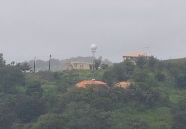
Randonnée pour les avertis, bien qu'elle soit à porté de tous, cette rando présente certaines difficultés qui surprend le randonneur mal équipé. soleil, montés, enrochement et végétaux épineux. cependant c'est une belle randonnée côtière qui se laisse courtiser à trou cochon pour un bain relaxant. c'est à 3 1/4 d'heures de la fin.